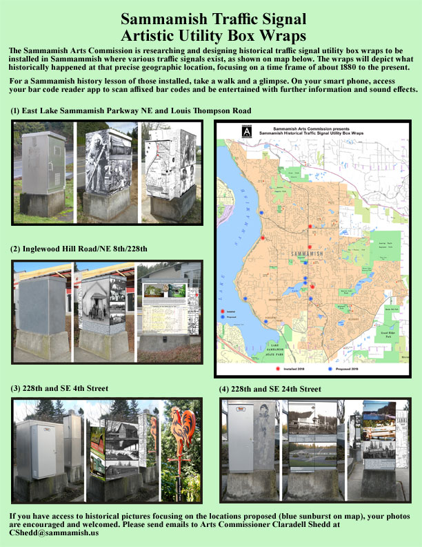
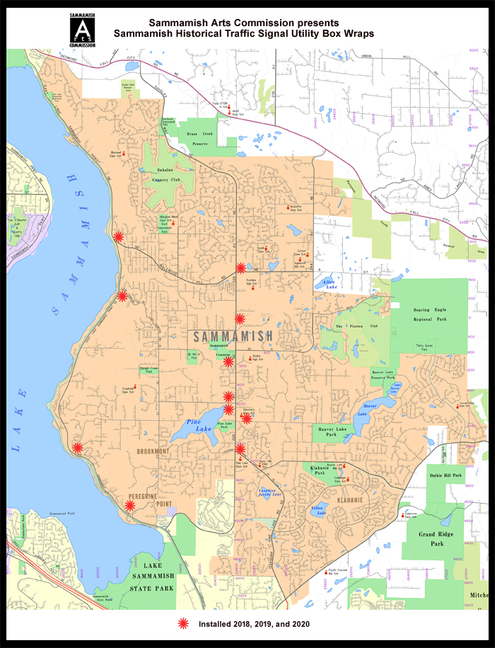
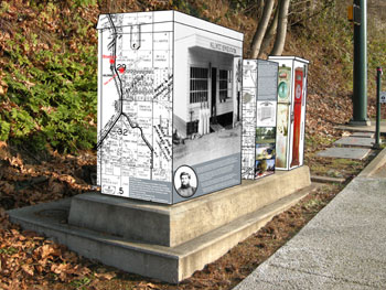
| Project-Utility
Box Wraps; 2018-2020 |
| Pictured below are the first four installations
completed in 2018. |
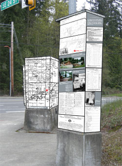
Three Stages of Box; East Lake Sammamish
Parkway & Louis Thompson Road
(drone 10/22/19: https://youtu.be/-VUO_x1V5iU
) |
 |
 |
 |
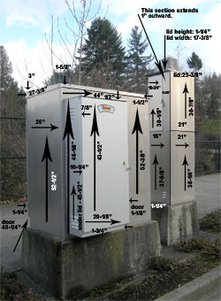
| East Lake Samm Pkwy PCab, Serv. |
East Lake Samm Pkwy Measurements |
East Lake Samm Pkwy West Elevation |
 |
Three Elevations of Box; 228th and Inglewood
Hill Road (4th Street NE)
(drone: 10/23/19: https://youtu.be/MWajnbXXsfA
) |
 |
 |
 |
| P Cabinet and Tesco Extension |
Southwest Elevation |
East Elevation |
|
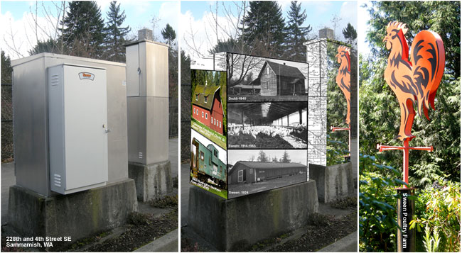
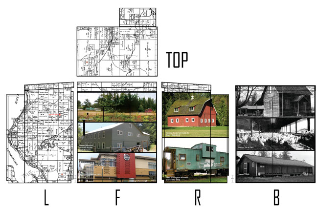
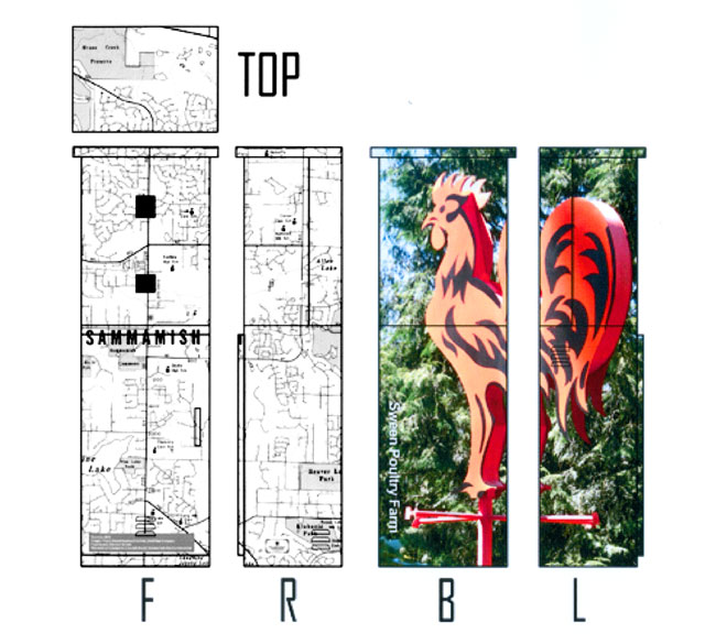
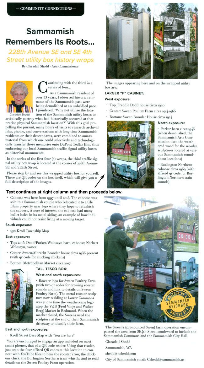
Three Stages of Two Boxes; 228th and 4th
Street SE (Metropolitan Market)
(drone: 10/23/19: https://youtu.be/6xuWVqKAmjA
) |
 |
 |
 |
| Met Mkt: P Cabinet and Service
Box |
Met Mkt: Measurements |
Met Mkt West Elevation |
|
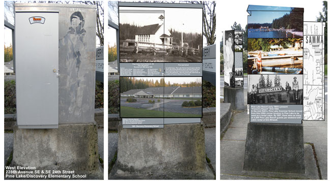
Three Elevation of Two Boxes;
228th and 24th Street SE (Pine Lake/Discovery School)
(drone: 10/23/19: https://youtu.be/dcqr54jT31Q
) |
 |
 |
 |
| P Cabinet and Tesco Extension |
Pine Lake/Discovery Southwest
Elevation |
Pine Lake/Discovery Southeast
Elevation |
|
A series
of articles is being written on each individual installation.
(text submitted for the first two articles appears below) |
 |
|
|
Article for Sammamish Neighbors Magazine
regarding installation at East Lake Sammamish Parkway NE and Louis Thompson
Road NE, Sammamish, WA . Appeared in January, 2019 issue.
Wednesday, September 26, 2018
Sammamish remembers its roots…
Our modern day Sammamish began creating roots for our community approximately
163 years ago with the 1855 Point Elliott Treaty In the Washington
Territory. East Coast residents made their treks toward the unexplored
and uncharted West Coast, lured by the Gold Rush in California (1948-1855)
and the Federal Homestead Act of 1862 (signed into law by Abraham
Lincoln on May 20, 1862). The Homestead Acts were several laws in
the United States by which an applicant could acquire ownership of
government land or the public domain, typically called a "homestead."
In all, more than 270 million acres of public land, or nearly 10%
of the total area of the U.S., was given away free to 1.6 million
homesteaders; most of the homesteads were west of the Mississippi.
Families made the covered wagon arduous journey via the Oregon Trail.
Those settling in California and Oregon extended their migration to
enter our present Washington State. Claimants (adult heads of families)
were required to "improve" the plot by building a dwelling
and cultivating the land, most often comprised of 160 acres of surveyed
public land. After five years on the land, the original filer was
entitled to the property, free and clear, except for a small registration
fee. Title could also be acquired after only a six-month residency
and minor improvements, provided the claimant paid the government
$1.25 per acre. After the Civil War, soldiers could deduct the time
they had served from the residency requirements. Of some 500 million
acres dispersed by the General Land Office between 1862 and 1904,
only 80 million acres went to homesteaders because few laborers and
farmers could afford to build a farm or acquire necessary tools, seed
and livestock.
Native American tribal communities populating the Washington Territory
included Chinook, Duwamish, Muckleshoot, Sammamish, Skokomish, Snohomish,
Snoqualmie, Stillaguamish, Suquamish, Tulalip, Walla Walla, and Yakima.
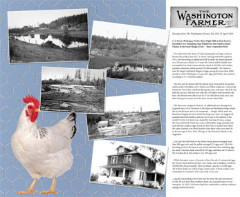
Seasonal tribal residents worked in the hops fields, logging, and
coal mines. During the hop field harvesting, they were here. Most
tribal residents then walked back to their other communities as far
away as Yakima. Yes, they walked back!
Rumored consideration on naming the city at the time of incorporation
on August 31, 1999, had included Sahalee, Inglewood, Pine Lake, Timberline,
Monohon, and Heaven (a proposition quickly withdrawn).
The name Sammamish is derived from "samma" meaning "the
sound of the blue crane" and "mish", meaning "river."
Another source says its name is derived from the Native American words
"samena" meaning "hunter", and "mish"
meaning "people."
Lake Sammamish was originally named Squak Lake. Sammamish itself has
been formerly named Adelaide, Gilman, Inglewood, Issaquah, Monohon,
and Pine Lake.
Several years ago, local Arts Commissioner Claradell Shedd proposed
to the Sammamish City Council that a project be entertained to "artistically
wrap" local traffic signal utility boxes. Two members considered
the idea premature and untimely, so the prospect of the project was
shelved, but not forgotten. When other local jurisdictions began artistically
wrapping their respective utility boxes, the Sammamish City Council
requested that the Sammamish Arts Commission, specifically Claradell
Shedd, revisit the project and produce representative samples.
Sammamish residents of over 32 years, the Shedds observed historic
remnants of the Sammamish past were being demolished at an unbridled
pace. Claradell Shedd pondered, "Why not utilize the location
of the Sammamish utility boxes to artistically portray what had historically
occurred at that precise physical Sammamish location?" With this
goal propelling the pursuit, many hours of visits to research archival
files, photos, and conversations with long-time Sammamish residents
or their descendants have combined to amass material from which one
could selectively and technologically transfer those memories onto
exclusive DuPont TW 360c/TW 360hd protectant, chemical resistant Tedlar
film embracing our local Sammamish traffic signal utility boxes.
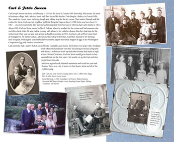
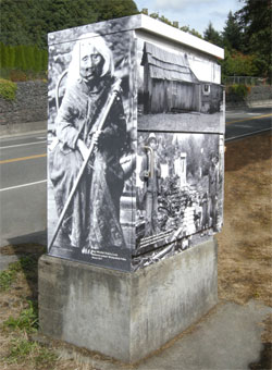
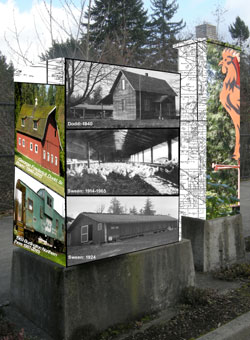
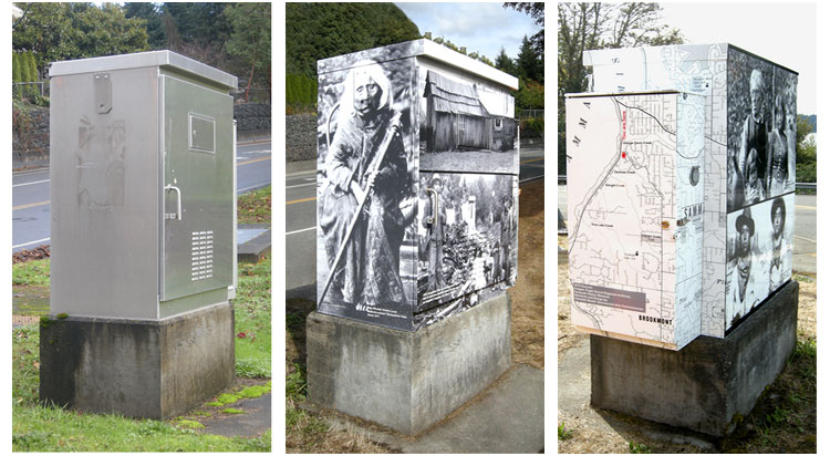
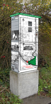
The first installation is located at the corner of East Lake Sammamish
Parkway NE and Louis Thompson Road (Louis Tahalthkut from U.S. Department
of Labor Bureau of Land Management records dated June 8, 1888). Images
include
(1) Mary Whullah Grahm Louie, the local Snoqualmie Tribal
Medicine Woman, who, various texts indicate, often pulled her canoe
up to that approximate location.
(2) James Zackuse, his wife, Amelia Brown Zackuse, and
son, Lolota (Snoqualmie).
(3) Edward and Louisa Johnny Davis family with daughters
Elizabeth and Hazel (Snoqualmie).
(4) Kelly Louis Louie and James Louie, grandsons of Mary
Whullah Grahm Louie (Snoqualmie).
(5) Davis residence (U.S. Dept of Interior Bureau of Land
Management records indicate George Davis, February 7, 1893)
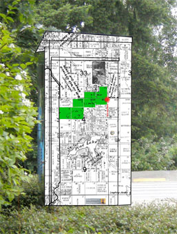
(6) Kroll Street Base Map on which I've typed in locations
for George Davis Creek, Zackuse Creek, Ebright Creek, and Pine Lake
Creek. On each map, you will find indicated "You are here".
(7) Top of box (which is not easily viewed because of
the height): Kroll 1958 Township map showing parcel ownership
Technically, the process I employ is:
(a) Photograph each elevation; i.e., north, south, east, west
(b) Measure the utility boxes up to ¼" precision
to include vents, police doors, popouts, etc.
(c) Exhaustively research "What happened here or
who lived here?"
(d) Pursue images of those events/individuals. All images
must be at least 600 dpi to achieve maximum clarity and precision.
(e) Utilizing Photoshop, Illustrator, and other software
packages, I restore those very often damaged images and "fit"
them into the elevation desired. (I had already sat at the intersection
and determined what would be the desirable image to observe for the
northbound, southbound traffic, etc. Obviously, the selection for
stoplight pausing would be for pictorial images, and the text would
be confined to an elevation where one would be walking.)
(f) Submit all proposed elevations to the contractor who
transfers my research, design, and layout to the final film product.
(g) The printed final film product is installed by very
artistically professional installers. (Walk up to one of the locations
and observe the incredible precision of the installation.)
Summarizing, the project is requiring:
(1) Being a caring and involved Sammamish resident
(2) Being a member of the Sammamish Heritage Society
(3) Creating a Sammamish Heritage Tree on ancestry.com
as a tool to locate historic records of Sammamish residents and former
residents. (I have established over 4,400 individual profile pages
in this search.)
(4) Being a graphic artist. After retiring, I re-entered
the "go back to school" environment, obtaining my credentials
in website design with graphic design emphasis (I have 40 nonprofit
websites; grade school, junior high, high school, college, quilting,
etc.)
(5) Being a Sammamish Arts Commissioner. I am dedicating
hundreds of hours in this focus to share the historic depth of our
wonderful City.
After each installation is completed, I am generating QR codes to
incorporate GPS or sounds, this QR code being affixed to a box at
each location. Pedestrians utilizing the qr code reader app on their
cell phones can scan the QR code with the resultant hyperlink taking
one to an appropriate specific online page on the Sammamish Heritage
Society's website or youtube for sounds. One can then access a much
more detailed history of that specific location. There are affixed
QR codes for "a rooster crowing, chickens clucking, trains whistling,
etc." I am incorporating images using my drones which can illustrate
a "current vista" next to that of the same location in the
1800's. I will utilize augmented reality technology on the wraps for
additional images. My intent/goal is to create through these traffic
signal wraps a historic walking and driving tour of Sammamish. The
proposed plan includes eleven (11) Sammamish geographic locations
encompassing twenty-two (23) different boxes.
As already requested, the local schools will be offered "field
trips" to supplement student exposure to the heritage of our
community. Citizens who have access to historic photos of this area
are encouraged to share those images with me for consideration of
additional planned installations. The plan is to publish a separate
informative and descriptive article on each individual installation.
A Powerpoint presentation is being created for future local presentations.
A youtube will eventually be posted which will contain specifics on
all eleven installed locations.
"In the end, our society will be defined not only by what we
create, but by what we refuse to destroy." John Sawhill
Claradell Shedd
Sammamish, WA
[email protected]
|
|
 |
|
|
Article for Sammamish
Neighbors Magazine regarding installation at 228th NE and Inglewood
Hill Road (NE 8th), Sammamish, WA. Appearing in February, 2019 issue.
Tuesday, January 15, 2019
Sammamish remembers its roots…Inglewood Grammar School
Our modern day Sammamish began creating roots for our community approximately
163 years ago with the 1855 Point Elliott Treaty In the Washington
Territory. East Coast residents made their treks toward the unexplored
and uncharted West Coast, lured by the Gold Rush in California (1948-1855)
and the Federal Homestead Act of 1862 (signed into law by Abraham
Lincoln on May 20, 1862). The Homestead Acts were several laws in
the United States by which an applicant could acquire ownership of
government land or the public domain, typically called a "homestead."
In all, more than 270 million acres of public land, or nearly 10%
of the total area of the U.S., was given away free to 1.6 million
homesteaders; most of the homesteads were west of the Mississippi.
Families made the covered wagon arduous journey via the Oregon Trail.
Those settling in California and Oregon extended their migration to
enter our present Washington State. Claimants (adult heads of families)
were required to "improve" the plot by building a dwelling
and cultivating the land, most often comprised of 160 acres of surveyed
public land. After five years on the land, the original filer was
entitled to the property, free and clear, except for a small registration
fee. Title could also be acquired after only a six-month residency
and minor improvements, provided the claimant paid the government
$1.25 per acre. After the Civil War, soldiers could deduct the time
they had served from the residency requirements. Of some 500 million
acres dispersed by the General Land Office between 1862 and 1904,
only 80 million acres went to homesteaders because few laborers and
farmers could afford to build a farm or acquire necessary tools, seed
and livestock.
Native American tribal communities populating the Washington Territory
included Chinook, Duwamish, Muckleshoot, Sammamish, Skokomish, Snohomish,
Snoqualmie, Stillaguamish, Suquamish, Tulalip, Walla Walla, and Yakima.
Seasonal tribal residents worked in the hops fields, logging, and
coal mines. During the hop field harvesting, they were here. Most
tribal residents then walked back to their other communities as far
away as Yakima. Yes, they walked back!
Rumored consideration on naming the city at the time of incorporation
on August 31, 1999, had included Sahalee, Inglewood, Pine Lake, Timberline,
Monohon, and Heaven (a proposition quickly withdrawn).
Lake Sammamish was originally named Squak Lake. Sammamish itself
has been formerly named Adelaide, Gilman, Inglewood, Issaquah, Monohon,
and Pine Lake.
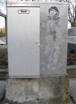
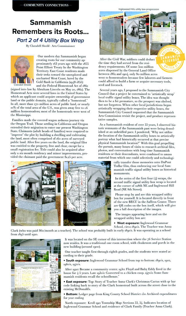
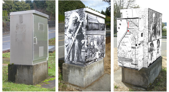
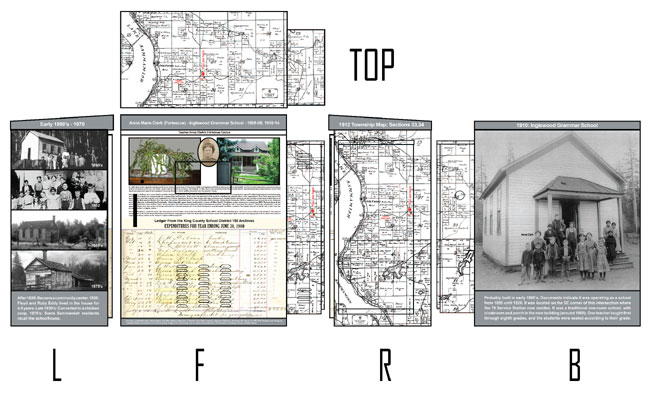
In the series of the first four (4) wraps, the second traffic signal
utility box wrap is located at the corner of 228th NE and Inglewood
Hill Road (NE 8th Street).
Images include:
- West exposure: Inglewood Grammar School, circa 1890's identifying
teacher Anna Clark. Text: "Probably built in early 1890's.
Documents indicate it was operating as a school from 1895 until
1920. It was located on the SE corner of this intersection where
the 76 Service Station now resides. It was a traditional one-room
school, with cloakroom and porch in the new building (around 1900).
One teacher taught first through eighth grades, and the students
were seated according to their grade.
"
- South exposure: Inglewood Grammar School from top to bottom: 1890's,
1902, 1960's, 1970's. Text: "After 1920: Became a community
center. 1930: Floyd and Ruby Eddy lived in the house for 4-5 years.
Late 1930's: Converted to a chicken coop. 1970's: Some Sammamish
residents recall the schoolhouse.
"
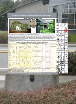
- East exposure: Top: Story of Teacher Anna Clark's Christmas Cactus
with qr bar code linking back to story of the Clark homestead built
across the street close to the existing McDonald's. "Sources:
Lucille McDonald, Kathryn Martin, Lily Mae Anderson interview of
Teacher Anna Clark Fortescue, Marymoor Museum, Redmond, WA, March
15, 1978. 2018: Research and Design by Claradell Shedd, Sammamish
Arts Commissioner. Images from Faye Sween, the Issaquah History
Museum, the Sammamish Heritage Society, Claradell Shedd"
Bottom: Ledger page from King County School District 150 Archived
expenditures for year ending June 30, 1910 (teacher Anna Clark's
salary shown as $60./month).
QR code linking to children in a one-room schoolhouse singing "School
Days."
- North exposure: Kroll 1912 Township Map: Sections 33, 34. Indicates
location of Inglewood Grammar School and residence of Clark Family
(Teacher Anna Clark) plus "You are here."
- Top: Kroll 1912 Township Map: Sections 33, 34. Tops are covered
because satellite maps can enlarge geographic areas to read details
of signage. After an installation is completed, I will be incorporating
drone photos of the tops of the units which should be a higher quality
than one can achieve with an enlarged satellite image.
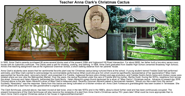
Text from Story of Teacher Anna Clark's Christmas Cactus:
"In 1906, Anna Clark's parents purchased 80 acres several blocks
west of the present 228th and Inglewood Hill Road intersection. For
about $600, her father built a two-story seven-room house with its
customary outhouse. The Clarks used a well for drinking, cooking,
and bathing. In 1908, Anna Clark graduated from Seattle High School
(renamed Broadway High School). Anna's first teaching assignment was
at the Inglewood Grammar School, a short walking distance from her
parents' house. Anna Clark's students were aware that her sentimental
favorite plant was her Christmas cactus being nurtured there at the
school. A young student named Freddie Dodd had performed admirably,
and Miss Clark wanted to acknowledge his commendable performance.
What could she give him which would be significantly representative
of her appreciation? Miss Clark approached her favorite plant, removed
a tendril, and presented it to Freddie. Inglewood farmers were chicken
and egg producers, and Freddie Dodd's family home and chicken coops
were located where we now view the Metropolitan Market. Over the years,
the cactus flourished under the care of Freddie and his mother, Bertha
Dodd. During the 1970's, neighbors from across the street, Donovan
and Helen Albrecht, befriended the Dodd family. Helen Albrecht's green
thumb beckoned for a sliver of "Miss Clark's" Christmas
cactus. Advance to present day 2018: Pictured above is the late Helen
Albrecht's sliver of Miss Clark's treasured plant. Recently Donovan
Albrecht asked a Sammamish resident, "Would you like a start
from the cactus?" Excitedly "Absolutely!" was the response.
Starts from this cactus are being cultivated on a kitchen window sill.
Anna Clark Fortescue's granddaughter has been located in Tennessee.
She will be gifted with a start from her late grandmother's original
cactus. The Clark farmhouse, pictured above, has been moved at last
twice, once in the late 1970's and in the 1990's, about a block further
west and has been continuously occupied. The present homeowners of
the Clark farmhouse will also become the recipients of a start from
Anna Clark's Christmas cactus 110+ years later! What could be more
appropriate than to return Anna Clark's original Christmas cactus
to her house in Inglewood/Sammamish?"
|
 |
| This is as the article appeared
in the February, 2019 issue of Sammamish Neighbors: |
 |
|
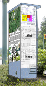
| Final Tri Graphic; East Lake Sammamish
Parkway & Louis Thompson Road |
 |
| Final Layout Proof; 228th and 4th Street
SE P Cabinet |
 |
|
| Tri-Graphic; 228th and Inglewood Hill road
(4th Street NE) |
 |
| Final Layout Proof; 228th and Inglewood
Hill Road (8th Street NE) |
 |
|
| Tri-Graphic to City Council; Met Market |
 |
|
|
| Final Layout Proof; 228th and 4th Street
SE; P Cabinet |
 |
| Final Layout
Proof; 228th and 4th Street S; Service Cabinet |
 |
| This is as the
article appeared in the March, 2019 issue of Sammamish Neighbors: |
 |
|
| Tri-Graphic;
228th and 24th Street SE (Pine Lake/Discovery) This includes 1890 kids'
reports cards, teacher's contract, etc.. |
 |
228thse24thpinelkdis.jpg) |
| This is as the
article is to appear in the April, 2019 issue of Sammamish Neighbors: |
Monday, April
8, 2019
Sammamish remembers its roots…228th Avenue SE and SE24th Street
(Pine Lake/Discovery School)
Continuing with the fourth in a series of four…. (another seven
locations comprised of thirteen more boxes proposed for 2019).
This installation contains a lengthy history lesson. Minnie Burney
Baker taught at Pine Lake Elementary around 1904. After Minnie had
married Earl Tucker Baker and was thereby forced to resign her teacher's
credentials as a result of her marriage, Minnie and Earl lived in
the historic Baker House which was moved on two occasions to eventually
be located on the premises of the common area of the Homeowners Association
of the present " The Laurels" off of SE24th Street between
Pine Lake and Beaver Lake. In 2018, the Association demolished the
Baker House. Earl and Minnie Baker had one son, Edward Baker, born
1910. Earl, Minnie, and their son Ed moved to Sammamish so that Ed
would be able to access special education services from the Issaquah
School District. The family moved to Sammamish after the Seattle School
District refused to serve their son, and Ed became one of the first
special education students to go through the Issaquah District.
When I was designing the wraps for the two boxes at this location,
I included a captivating photo of Minnie Burney Baker with their infant
son, Edward. In researching Edward's various activities while he lived
in Sammamish, I came across his obituary. In his obituary, I noted
that Edward was fascinated and heavily engaged in building projects
with Legos. The obituary said that for the last ten years of his life,
he celebrated his birthday by traveling to Legoland in Southern California.
My personal involvement with the Sammamish Arts Commission's annual
"Build It Sammamish/Lego Event" took me back to 2013 when
I remembered taking numerous photos of that event and its participants.
I vividly recalled an elderly man who was involved and very focused
in working with the Lego building units. I retrieved my archived 2013
Arts Commission photographs and there at that January 26, 2013 event
was Edward Baker! Edward Burney Baker died two months later, April
10, 2013, at the age of 103.
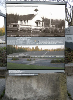
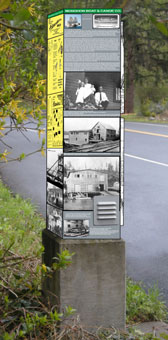
In the series of the first four (4) wraps, the fourth traffic signal
utility box wrap is located at the corner of 228th Avenue SE and SE24th
Street (near the entrance to Pine Lake Park). Images include:
Larger "P" cabinet:
- Northwest exposure: (photos approximately 1930's to present)
top: Pine Lake
center: Pine Lake
bottom: Local residents on the roof of the Pine Lake Grocery Store;
circa 1960
- Southwest exposure:
(1) Pine Lake School (1895-1940's)
(2) Lists Pine Lake School teachers from various years (1895-1923).
(3) Discovery School; built 1991
- Southeast exposure:
1912 Kroll Township Map (two sides) "You are here" showing
location
" Top of "P" cabinet: Continuation of 1912 Kroll
Township Map
Tall Skyline Box:
- North exposure: Large photo, circa 1910, of Minnie Burney Baker
(1885-1977) with son Edward (1910-2013)
- Northwest exposure: (1-3) Three versions of Baker House; top/1920,
next down; 2012; next down 2018 (4) Bakers farming; circa 1925;
(5) Bakers farming; circa 1925
- East exposure:
(1) Text explaining requirements/qualifications of teachers; (2)
teachers' contract, circa 1923; (3) Attendance record, circa
1890; (4) Grade (report card entries) and school district subjects;
1895; students Leo and Agnes Goebel, circa 1900; Inventory of Movable
Property (alarm clock, broom, etc.) circa 1922
- Southeast exposure:
(1-2) King County Assessor's Maps; 1956 and 1946; (3) Three photos
of Pine Lake waterfront; circa 1966; (4) Pine Lake School children;
circa 1913; (5) District Library Record; circa 1920-1922; (6) Minnie
Burney Baker's 1904 Teacher's Certificate
- Top of Skyline cabinet: 10 Loggers; Pine Lake/Settum and Jones
Shake Mill; 1909-1911
Stop by this location and engage an app included on most smart phones,
that of a qr code reader. Using that reader, just scan the externally
affixed qr codes at this location to connect with youtube files to
hear the horses neigh, logging sounds, the kids singing "School
Days", etc..
|
| NOTE: This project could
not have been executed without the genuine and sincere efforts of the
following employees at TrafficWrapZ: (1) Herb Kiekenapp, Global Director
and local coordinator of all details, (2) Dan Gittere, VP of TrafficWrapZ,
(3,4) Pablo Marin and Latashia Benjamin, genius layout designers and
publication experts, and (5) Nick Nagel, indescribable exceptional installation
artist.. This is a professional privilege to experience how this organization
listens, executes, and assures satisfaction of a quality product. |
| Below
is the entry included in the 2018 Winter REC Guide of a Sammamish City
Newsletter |
 |
 |
These are on the drawing board for
East Lake Sammamish Parkway NE and Inglewood Hill Road NE
(Sammamish's First Service Station and First Post Office) |
 |
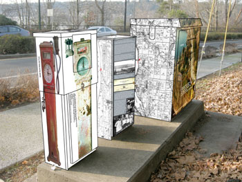 |
Southwest
Elevation of
East Lake Sammamish Parkway NE and Inglewood Hill Road NE |
Northeast
Elevation of
East Lake Sammamish Parkway NE and Inglewood Hill Road NE |
|
Each box installation provides a
poignant Sammamish story. These boxes describe how this
land was sectioned in 1895 to entice individuals to acquire "Lake
Sammamish waterfront." |
 |
 |
1895: Lots
platted at Inglewood, WA at intersection
of East
Lake Sammamish Parkway NE and Inglewood Hill Road NE |
Four-time Mayor Sammamish,
Don Gerend, shares his personal experience. |
|
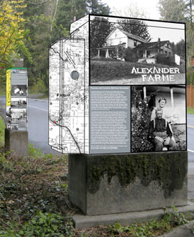
(In Work)
Six Elevations of Proposed Box; East Lake Sammamish Parkway & 212th
SE (Sunderhauf Road)
(Alexander's Beach and Resort) |
 |
 |
 |
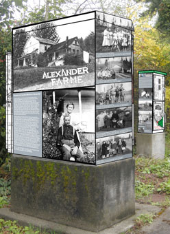
Pictured
above:
Left exposure, top to bottom, P cabinet
Alexander Family Homestead located at corner of East
Lake Sammamish Parkway SE and present 205th Avenue SE (Eagle Ridge)
Thomas and Caroline McKivor Alexander circa 1912
1958 Kroll Township Map
Photo on top of P cabinet is of Alexander's Monohon
Donkey Crew; circa 1924-1927
Smaller Skyline cabinet in rear contains.
Brochures from Alexander's Beach
Alexander's Beach Resort slide on Lake Sammamish;
circa 1930's
Mayflower to Monohon Canoe images
|
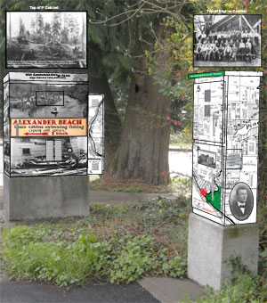
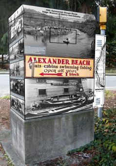
Pictured
above:
Left side exposure, top to bottom, P cabinet
Cabinet top: Loggers above Alexander's Beach Monohon
Crew; 1924-1927
1960: Racing on Sammamish Slough
Alexander's Beach Resort sign
1908: John Otto Sunderhauf and Alden Rutherford
Kingsbury in front of their Monohon Boat and Canoe Company at Monohon
1958 Kroll Township Map
Right exposure, top to bottom; Skyline cabinet:
Top of Skyline Cabinet; Monohon Mill #2; 1933-1939
Sunderhauf Road header
1958 Kroll Township Map showing Sunderhauf property
and location of Alexander's Beach Resort
Photo of Alden Rutherford Kingsbury, co-founder of
Monohon Boat and Canoe Company
Photo of 1909 house of John Otto Sunderhauf, co-owner
of Monohon Boat and Canoe Company
|
Pictured
above:
Cabinet top: Monohon Mill #2; 1933-1939
Left exposure, top to bottom:
Monohon Boat and Canoe Company header
Text story of "From the Mayflower
to Monohon Canoe"
Monohon Boat and Canoe photos; circa 1908-1913
Right exposure, top to bottom:
Sunderhauf Road header
1958 Kroll Township Map
indicating location of Alexander's Beach Resort and Sunderhauf parcels
(in green)
1940 Photo of 1909-built house of John Otto Sunderhauf,
co-owner of Monohon Boat and Canoe Company. Car is 1931 Ford Model
T.
|
 |
 |
 |
Pictured
above:
Photo on top of P cabinet is of Alexander's Monohon Donkey
Crew; circa 1924-1927
Left exposure, top to bottom, P cabinet
Alexander Family Homestead located at corner of East
Lake Sammamish Parkway SE and present 205th Avenue SE
Thomas and Caroline McKivor Alexander circa 1912
Alexander/Ek/Haro/Olson/Crossley family photos
1958 Kroll Township Map
Smaller Skyline cabinet in rear contains:
Brochures from Alexander's Beach
Alexander's Beach Resort slide on Lake Sammamish;
circa 1930's
Mayflower to Monohon Canoe story with pictures
|
Pictured
above:
P cabinet
Cabinet top: Loggers above Alexander's Beach Monohon
Crew; 1924-1927
Left exposure, top to bottom
Alexander/Ek/Haro/Olson/Crossley family photos
Front exposure, top to bottom
1960: Racing on Sammamish Slough
Alexander's Beach Resort sign
1908: John Otto Sunderhauf and Alden Rutherford
Kingsbury in front of their Monohon Boat and Canoe Company at Monohon
1958 Kroll Township Map on side
|
Pictured
above:
Cabinet top: Monohon Mill #2; 1933-1939
Left exposure, top to bottom:
Alexander's Beach Resort header
Brochurees from Alexander's Beach Resort
Alexander's Beach Resort slide on Lake
Sammamish; circa 1930's
Matt Mattila family photos; circa 1917 and 1924
Right exposure, top to bottom:
Monohon Boat and Canoe Company header
Photos of Monohon Boat and Canoe Company and story
of "From the Mayflower to Monohon Canoe"
Alden Rutherford Kingsbury family photo; circa 1912
|
 |
The above material
will appear on the Proposed Box Design; East Lake Sammamish Parkway
& 212th SE (Sunderhauf Road)
(Alexander's Beach and Resort) |
| (In Work) Three
Elevations of Proposed Box; East Lake Sammamish Parkway & 24th Way
SE (flashing light) |
 |
 |
 |
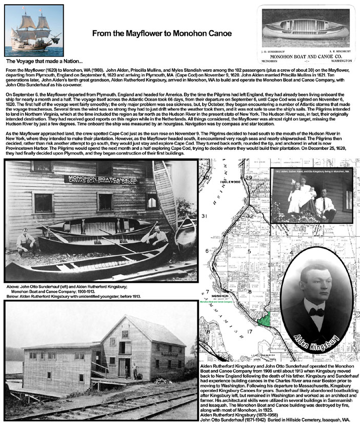
Pictured above:
Left exposure, top to bottom:
"Chapel Hill Road" sign
Lakeview Chapel on corner of East Lake Sammamish
Parkway SE and Chapel Hill Road (SE24th Way)
Preacher Ben Willis; circa 1940's
Arie & Jakoba Pillie Family,
1919/Netherlands
Right exposure, top to bottom:
Meindert Pillie Lakefront; circa 1943
Ted & Nellie Mae Nolet Family; late 1930's-early
1940's
Pillie Pile Driver on Lake Sammamish; circa 1943
|
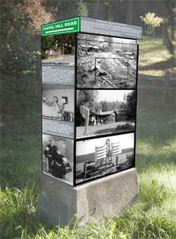
Pictured above:
Left side exposure, top to bottom:
Meindert Pillie Lakefront; circa 1943
Ted & Nellie Mae Nolet Family; late 1930's-early
1940's
Pillie Pile Driver on Lake Sammamish; circa 1943
Right exposure, top to bottom:
"Was Chapel Hill Road" sign
Annie Cary (Costello); circa 1940
James McNabb with son Kirk; circa 1951
Bud and Shirley McNabb with son Doug; circa 1950
on frozen Lake Sammamish
|
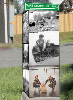
Pictured above:
Left exposure, top to bottom:
1958 Kroll Township Map showing properties
for Brown, McNabb, Pillie, Schumacher
Right exposure, top to bottom:
"Chapel Hill Road" sign
Lakeview Chapel on corner of East Lake Sammamish
Parkway SE and Chapel Hill Road (SE24th Way)
Preacher Ben Willis; circa 1940's
Arie & Jakoba Pillie Family, 1919/Netherlands
|
| Music:
"Let There Be Peace" |
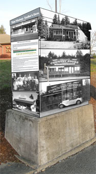
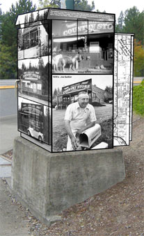
| (In Work) Three Elevations
of Proposed Box; 228th Avenue SE and Issaquah-Pine Lake Road SE (Sadlier's
Store) |
 |
 |
 |
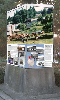
| Image
recognizing equestrian activity on the Plateau appearing on the top
of the large P cabinet above. |
| Explanation of images to
follow. |
| (In Work) Three Elevations
of Proposed Box; 228th Avenue SE and SE 8th Street (City Hall) |
 |
 |
 |
|
|
| Explanation of images to
follow. |
| Location at 228th Avenue
SE and SE 16th Street coming: one
graphic is Andrew Holsten bio page |
| |
Home
| Locations
| No.1 Box | No.2
Box | No.3 Box | No.4
Box | No.5 Box | No.6
Box | No.7 Box |
No.8 Box |
No.9 Box | No.10 Box | No.11
Box | Harry Military
| Sammi Award | Golf
|
Claradell Hall of Fame | Volunteer
| Skates | Contact
| Projects | City
Council
©2023-csheddgraphics All rights reserved.
All images and content are © copyright of their respective copyright
owners. |
|